


Three Notch Road
LEXINGTON PARK, MD 20653
Map
- – beds
- – baths
- – sqft
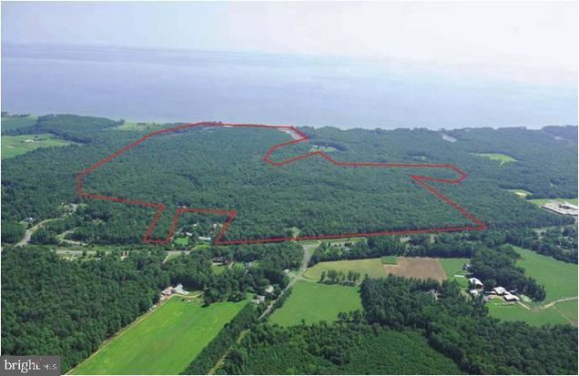
- ~390 acre lot
RARE OPPORTUNITY - 390 ACRES - CHESAPEAKE BAY WATERFRONT: Sale Includes Two (2) Parcels Consisting of 390 Acres +/- of Wooded Land w/ Approx. 1000 LF of Waterfront and Expansive Views. Potential of Eight (8) Building Lots, Marketable Timber or Incredible Hunting, Fishing and Recreational Land with Deer and Turkey. Property also Affords 2,000 LF of Road Frontage Along Three Notch Road (MD Route 235) and Only Minutes from Patuxent River Naval Air Station. Zoning is Residential Preservation or Residential Preservation - Open Space. Property is also Subject to Restrictions from Maryland Environmental Trust (MET) Easements. Showings By Appointment Only!
![]()
Last checked:
As a licensed real estate brokerage, Estately has access to the same database professional Realtors use: the Multiple Listing Service (or MLS). That means we can display all the properties listed by other member brokerages of the local Association of Realtors—unless the seller has requested that the listing not be published or marketed online.
The MLS is widely considered to be the most authoritative, up-to-date, accurate, and complete source of real estate for-sale in the USA.
Estately updates this data as quickly as possible and shares as much information with our users as allowed by local rules. Estately can also email you updates when new homes come on the market that match your search, change price, or go under contract.
![]() Checking…
•
Last updated Jun 26, 2025
•
Checking…
•
Last updated Jun 26, 2025
•
MLS# MDSM2025746 —
Financial & Terms
-
Sale Type:Standard
-
Possession:Settlement
Location
-
Directions:FROM PAX RIVER (Patuxent River Naval Air Station): Follow Three Notch Road (MD Route 235) South & Property is Located on LEFT (Immediately to the South of Poplar Ridge Road).
-
Latitude:38.22310000
-
Longitude:-76.39961200
The Property
-
Property Type:Land
-
Property Subtype:Land
-
Current Use:Vacant
-
Lot Size Units:Square Feet
-
Lot Size Acres:390.43
-
Lot Size Source:Estimated
-
Lot SqFt:17,007,130 Sqft
-
Additional Parcels:Yes
-
Additional Parcels:St. Mary's County Tax Id #01 018558 (210.93 Acres +/ ) St. Mary's County Tax Id #01 030175 (179.5 Acres +/ )
-
Zoning Description:Rural Preservation & Rural Preservation - Open Space
-
Zoning:RP
-
In City Limits:No
-
Waterview:No
-
Waterfront:No
-
Water Oriented:No
-
Water Access:No
-
Navigable Water:No
-
Tidal Water:No
-
Farm Land Preservation:No
-
Riparian Rights:No
Listing Agent
- Contact info:
- Agent phone:
- (301) 870-5841
- Office phone:
- (301) 870-5841
Taxes
-
Tax ID Number:1901030175
-
Tax Year:2024
-
Tax Annual Amount:$2,050.11
-
Total Taxes Payment Frequency:Annually
Utilities
-
Sewer/Septic:Other
-
Water Source:Well Required
Schools
-
Middle School:Spring Ridge
-
High School:GREAT MILLS
-
School District Name:St. Marys County Public Schools
-
School District Source:3rd Party
The Community
-
Subdivision Name:None Available
-
Association Recreation Fee:No
-
HOA:No
-
Condo/Coop Association:No
Extra Units
-
Vacation Rental:No
Walk Score®
Provided by WalkScore® Inc.
Walk Score is the most well-known measure of walkability for any address. It is based on the distance to a variety of nearby services and pedestrian friendliness. Walk Scores range from 0 (Car-Dependent) to 100 (Walker’s Paradise).
Bike Score®
Provided by WalkScore® Inc.
Bike Score evaluates a location's bikeability. It is calculated by measuring bike infrastructure, hills, destinations and road connectivity, and the number of bike commuters. Bike Scores range from 0 (Somewhat Bikeable) to 100 (Biker’s Paradise).
Sale history
| Date | Event | Source | Price | % Change |
|---|---|---|---|---|
|
6/26/25
Jun 26, 2025
|
Listed / Active | BRIGHT | $4,500,000 |