


Tbd SE County Road 1070
Corsicana, TX 75109
Map
- – beds
- – baths
- – sqft
- ~231 acre lot
- – on site
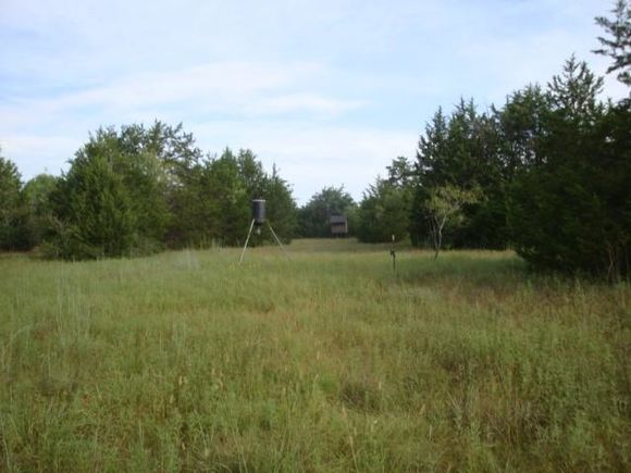
Looking for that rare opportunity to own a larger piece of native property for recreational or wildlife potential? This 231-236 acre property offers it! Make your dreams a reality. Multiple land tracts joined together for this sale offering. Water and electricity run along SE CR 1070. Located just 10 miles South of Corsicana with close access to I45 on SE County Road 1070 south of Corsicana between Dallas and Houston with good road frontage and featuring native grasses, hardwood trees and dry weather creeks. Deer and other wildlife are found on the property Also close access to Richland-Chambers Lake where unlimited fishing and recreational opportunities abound. Come and imagine the potential possibilities of this property for yourself.
![]()
Last checked:
As a licensed real estate brokerage, Estately has access to the same database professional Realtors use: the Multiple Listing Service (or MLS). That means we can display all the properties listed by other member brokerages of the local Association of Realtors—unless the seller has requested that the listing not be published or marketed online.
The MLS is widely considered to be the most authoritative, up-to-date, accurate, and complete source of real estate for-sale in the USA.
Estately updates this data as quickly as possible and shares as much information with our users as allowed by local rules. Estately can also email you updates when new homes come on the market that match your search, change price, or go under contract.
![]() Checking…
•
Last updated Jul 14, 2025
•
Checking…
•
Last updated Jul 14, 2025
•
MLS# 20995573 —
Location
-
Directions:From Corsicana take I 45 S 9.6 miles to N FWY Service Rd Exit, turn left on N Fwy Service Rd. and cross over I45, turn right on N Fwy Service Ro., go 300 feet, turn left on SE County Rd 1070, go appoximately 1 mile. Property on the left, sign on the entrance gate to the property.
-
Latitude:31.96950655
-
Longitude:-96.40653492
The Property
-
Property Type:Land
-
Property Subtype:Unimproved Land
-
Parcel Number:42471
-
Lot Features:Acreage, Agricultural
-
Lot Size:Over 100 Acres
-
Lot Size SqFt:10079348.4000
-
Lot Size Acres:231.3900
-
Lot Size Area:231.3900
-
Lot Size Units:Acres
-
Easements:Access
-
Restrictions:None
-
Current Use:Agricultural, Hunting/Fishing
-
Possible Use:Agricultural, Cattle, Development, Grazing, Hunting/Fishing, Livestock, Pasture, Ranch, Recreational, Single Family
-
Exclusions:Minerals.
-
Zoning Description:None
-
Fencing:Barbed Wire
-
Crops:Bluestem, Native
-
Soil Type:Sandy Loam
-
Vegetation:Brush, Wooded
-
Acres Pasture:231.39
-
Road Frontage Type:County Road
-
Will Subdivide:No
-
Land Lease:No
Listing Agent
- Contact info:
- No listing contact info available
Taxes
-
Tax Legal Description:ABS A10008 J MCNEAL ABST TRACT 100 64.0 ACRES
The Listing
-
Virtual Tour URL Unbranded:https://www.propertypanorama.com/instaview/ntreis/20995573
Utilities
-
Utilities:Electricity Available, Gravel/Rock
Schools
-
School District:Mildred ISD
-
Elementary School:Mildred
-
Elementary School Name:Mildred
-
Middle School Name:Mildred
-
High School Name:Mildred
The Community
-
Subdivision Name:None
-
Association Type:None
-
Development Status:Unzoned
Walk Score®
Provided by WalkScore® Inc.
Walk Score is the most well-known measure of walkability for any address. It is based on the distance to a variety of nearby services and pedestrian friendliness. Walk Scores range from 0 (Car-Dependent) to 100 (Walker’s Paradise).
Bike Score®
Provided by WalkScore® Inc.
Bike Score evaluates a location's bikeability. It is calculated by measuring bike infrastructure, hills, destinations and road connectivity, and the number of bike commuters. Bike Scores range from 0 (Somewhat Bikeable) to 100 (Biker’s Paradise).