
Tbd Fm 2456
Ladonia, TX 75449
- – beds
- – baths
- – sqft
- ~50 acre lot
- – on site
More homes
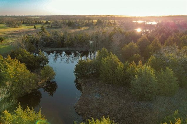
Discover nearly 50 acres of diverse Texas countryside, just 5 miles from the future 7,600-acre Lake Ralph Hall. This undeveloped land offers endless possibilities to build your dream country home, develop, or create the ultimate recreational retreat. Featuring two large ponds that provide excellent fishing and waterfowl hunting, while approximately 25 acres of wooded habitat create a haven for deer, hogs, predators, and small game. Just outside Ladonia city limits with no floodplain, only minutes from HWY 50 & HWY 34 for easy access to major routes. Less than 90 minutes from the DFW suburbs. Electricity on-site, county water available, 730 feet of road frontage, and a gated entrance with partial fencing. Fully AG-exempt for significant tax savings. With its prime location near one of Texas' largest future recreational lakes, this is a rare opportunity to invest in a piece of Texas country before demand soars!
![]()
Last checked:
As a licensed real estate brokerage, Estately has access to the same database professional Realtors use: the Multiple Listing Service (or MLS). That means we can display all the properties listed by other member brokerages of the local Association of Realtors—unless the seller has requested that the listing not be published or marketed online.
The MLS is widely considered to be the most authoritative, up-to-date, accurate, and complete source of real estate for-sale in the USA.
Estately updates this data as quickly as possible and shares as much information with our users as allowed by local rules. Estately can also email you updates when new homes come on the market that match your search, change price, or go under contract.
![]() Checking…
•
Last updated May 19, 2025
•
Checking…
•
Last updated May 19, 2025
•
MLS# 20871371 —
Location
-
Directions:Drive south on HWY 50 from Ladonia to left on FM 2456. Property is approximately 2.7 miles on the right.
-
Latitude:33.41390200
-
Longitude:-95.92355000
The Property
-
Property Type:Land
-
Property Subtype:Unimproved Land
-
Parcel Number:000000111119
-
Lot Features:Acreage, Agricultural, Brush, Cleared, Level, Many Trees, Pasture, Tank/ Pond, Undivided, Water/Lake View
-
Lot Size:10 to < 50 Acres
-
Lot Size SqFt:2159269.2000
-
Lot Size Acres:49.5700
-
Lot Size Area:49.5700
-
Lot Size Units:Acres
-
Lot Size Source:Public Records
-
Subdivided:No
-
Easements:Access, Electric
-
Restrictions:None
-
Current Use:Agricultural, Hunting/Fishing, Investment, Pasture, Recreational, Timber, Unimproved, Vacant
-
Possible Use:Agricultural, Barndominium, Cattle, Development, Equine, Grazing, Horses, Hunting/Fishing, Investment, Livestock, Manufactured Home, Mobile Home, Pasture, Ranch, Recreational, Residential, Single Family, Subdevelopment, Timber, Unimproved, Vacant
-
Exclusions:Hunting Blind, Game Feeders, Storage Container and Camper
-
Zoning Description:Agricultural- Native Pasture
-
Topography:Flat and slightly rolling hills
-
Fencing:Barbed Wire, Gate, Partial
-
Soil Type:Clay
-
Vegetation:Brush, Cleared, Grassed, Partially Wooded
-
Horse Permitted:Yes
-
Acres Pasture:18.00
-
# of Tanks And Ponds:3
-
Frontage Feet:700
-
Waterfront:No
-
Waterfront Features:Creek
-
Road Assessment:No
-
Road Frontage Type:FM Road
-
Road Surface Type:Asphalt
-
Road Frontage Distance:700
-
Will Subdivide:No
Listing Agent
- Contact info:
- No listing contact info available
Taxes
-
Tax Legal Description:A0575 J S JOHNSON, ACRES 49.57
The Listing
Utilities
-
Utilities:Co-op Electric, Co-op Water, Electricity Connected, Outside City Limits, Sewer Not Available
Schools
-
School District:Fannindel ISD
-
Elementary School:Fannindell
-
Elementary School Name:Fannindell
-
Middle School Name:Fannindell
-
High School Name:Fannindell
The Community
-
Subdivision Name:A0575
-
Senior Community:No
-
Association Type:None
-
Development Status:Unzoned
Walk Score®
Provided by WalkScore® Inc.
Walk Score is the most well-known measure of walkability for any address. It is based on the distance to a variety of nearby services and pedestrian friendliness. Walk Scores range from 0 (Car-Dependent) to 100 (Walker’s Paradise).
Bike Score®
Provided by WalkScore® Inc.
Bike Score evaluates a location's bikeability. It is calculated by measuring bike infrastructure, hills, destinations and road connectivity, and the number of bike commuters. Bike Scores range from 0 (Somewhat Bikeable) to 100 (Biker’s Paradise).