


Rock Island Road
PERRY, FL 32347
Map
- – beds
- – baths
- – sqft
- ~94 acre lot
- – on site
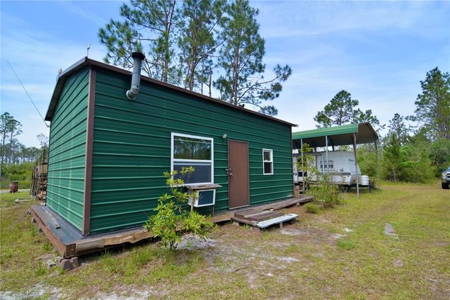
Located DEEP in the North Florida backwoods of San Pedro Bay, this unique offering includes two turnkey tracts of land, ready for immediate use as a hunting retreat or off-grid getaway. The northern 48.31-acre tract has been managed exclusively for hunting and recreation. It features approximately 1.3 miles of internal roads leading to several clearings equipped with game feeders, tree stands, and a box stand—easily accommodating 2–3 hunters at a time. The area is rich with whitetail deer, wild hogs, and turkeys, with many successful harvests over the years. A healthy mix of Live Oak, Water Oak, and Swamp Chestnut trees provides a natural food source, supporting local wildlife through the winter. To the south, the 45.32-acre tract hosts a fully functional off-grid hunting camp—perfect for outdoor enthusiasts. The centerpiece is a metal-frame cabin offering approximately 780 sq ft of heated and cooled living space. Inside, you’ll find a two-bed loft, one bathroom, a well-equipped kitchen with propane appliances, and a cozy living area ideal for relaxing after a day in the woods. The cabin is cooled by two window-unit air conditioners and heated with a wood-burning stove. A screened-in porch offers a peaceful spot to enjoy the sights and sounds of nature, while an overwatch tower in the backyard provides a clear view of the game feeder to the north. Although off-grid, the cabin features two reliable power sources: a 10 KW military-grade diesel generator and a solar power system with backup batteries. Switching between systems is easy, thanks to a conveniently located transfer switch in the screened porch. Additionally, a fifth-wheel camper sits under a sturdy metal carport, fully connected to power, well, and septic. It’s always ready for visiting hunters or extra guests looking to experience this remote slice of paradise.
![]()
Last checked:
As a licensed real estate brokerage, Estately has access to the same database professional Realtors use: the Multiple Listing Service (or MLS). That means we can display all the properties listed by other member brokerages of the local Association of Realtors—unless the seller has requested that the listing not be published or marketed online.
The MLS is widely considered to be the most authoritative, up-to-date, accurate, and complete source of real estate for-sale in the USA.
Estately updates this data as quickly as possible and shares as much information with our users as allowed by local rules. Estately can also email you updates when new homes come on the market that match your search, change price, or go under contract.
![]() Checking…
•
Last updated Jul 15, 2025
•
Checking…
•
Last updated Jul 15, 2025
•
MLS# OM700564 —
The Building
-
Building Area Units:Square Feet
Room Dimensions
-
Living Area Units:Square Feet
Location
-
Directions:From I-10, take Exit 258. Head southeast on County Road 53 for 5.2 miles. Turn right onto SW Tower Road and continue southwest for 2.4 miles, passing through a cattle gate (please close it behind you). Turn left onto Camp Road and drive south for 3.7 miles. Turn right onto County Line Road and continue west for 4.8 miles. Turn left onto Gum Road and drive south for 0.6 miles. Turn right onto Farr Road and go approximately 180 yards southwest. Turn left onto Rock Island Road and continue south for 1.2 miles. The property will be on your right.
-
Latitude:30.2364
-
Longitude:83.4262
-
Coordinates:83.4262, 30.2364
The Property
-
Parcel Number:09043575
-
Property Type:Land
-
Lot Size Acres:93.63
-
Lot Size Area:93.63
-
Lot Size SqFt:4078522
-
Lot Size Dimensions:695 x 2661 x 975 x 2916 x 632 x 1696 x 137
-
Lot Size Units:Acres
-
Total Acres:50 to less than 100
-
Zoning:SFR / VACA
-
Current Use:Residential
-
View:false
-
Water Source:Well
-
Road Surface Type:Dirt
-
Flood Zone Code:A,X
-
Additional Parcels:true
-
Additional Parcels Description:09039-390
-
Price Per Acre:4795
Listing Agent
- Contact info:
- Agent phone:
- (352) 359-7626
- Office phone:
- (217) 577-3699
Taxes
-
Tax Year:2024
-
Tax Block:N/A
-
Tax Legal Description:LEG 0045.32 ACRES - NORTH PART OF TRACT 57 - COM NW COR SECT 6 E 6452.43 FT N61D - E 159.65 FT N57DE 258.72 FT S13DE - 61.16 FT S9DE 165.68 FT S20DE 371.1 - FT S33DE 1086.8 FT S22DE 405.57 FT - S13DE 612.95 FT S8DE 605.4 FT S3DW - 334.26 FT S3DE 1251 .36 FT S4DW - 82.79 FT E 1622.4 FT S12DE 1888.81 - FT S17DE 1341.03 FT S28DE 1018.94 - FT FOR POB N86DE 2666.83 FT S45DE - 528.4 FT S44DE 102.07 FT S37DE - 112.54 FT S27DE 97.57 FT S16DE 96.8 - FT S7DE 27.89 FT W 2930.79 FT - N28DW 690.03 FT TO POB - TOGETHER WITH ESMTS - OR 644-611 -
-
Tax Book Number:644 / 611
-
Tax Annual Amount:$1,913.82
The Listing
-
Virtual Tour URL Unbranded:https://www.propertypanorama.com/instaview/stellar/OM700564
-
Special Listing Conditions:None
Utilities
-
Utilities:Electricity Available
-
Sewer:Septic Tank
The Community
-
Waterview:false
-
Water Access:false
-
Waterfront:false
-
Association:false
-
Ownership:Fee Simple
Walk Score®
Provided by WalkScore® Inc.
Walk Score is the most well-known measure of walkability for any address. It is based on the distance to a variety of nearby services and pedestrian friendliness. Walk Scores range from 0 (Car-Dependent) to 100 (Walker’s Paradise).
Bike Score®
Provided by WalkScore® Inc.
Bike Score evaluates a location's bikeability. It is calculated by measuring bike infrastructure, hills, destinations and road connectivity, and the number of bike commuters. Bike Scores range from 0 (Somewhat Bikeable) to 100 (Biker’s Paradise).
Sale history
| Date | Event | Source | Price | % Change |
|---|---|---|---|---|
|
6/24/25
Jun 24, 2025
|
Price Changed | STELLAR_MLS | $449,000 | -2.2% |
|
5/2/25
May 2, 2025
|
Listed / Active | STELLAR_MLS | $459,000 |