


N Hathaway / Hwy 27
Bronson, FL 32621
Map
- – beds
- – baths
- – sqft
- ~3 acre lot
- – on site
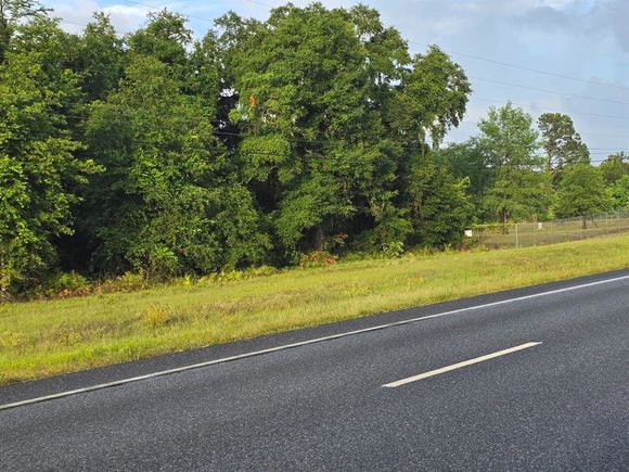
COMMERCIAL PROPERTY IN PRIME LOCATION ---2.62 acres - Zoned C1/C2 400 . Cleared and ready to build with frontage along US 27/E Hathaway Avenuel FL-500 in the city limits of Bronson (400 yards west of the traffic light). Bronson is centrally located to Gainesville, Ocala, Cedar Key, and the Suwannee River. Current zoning offers endless possibilities for business development, including retail, office space, or other commercial uses. This flat, easily buildable lot offers generous commercial frontage in an upcoming location—It is an amazing opportunity to get in while prices are still low. This is an exceptional opportunity to gain equity year after year in a rapidly developing area. Act now to take advantage of this outstanding investment!
![]()
Last checked:
As a licensed real estate brokerage, Estately has access to the same database professional Realtors use: the Multiple Listing Service (or MLS). That means we can display all the properties listed by other member brokerages of the local Association of Realtors—unless the seller has requested that the listing not be published or marketed online.
The MLS is widely considered to be the most authoritative, up-to-date, accurate, and complete source of real estate for-sale in the USA.
Estately updates this data as quickly as possible and shares as much information with our users as allowed by local rules. Estately can also email you updates when new homes come on the market that match your search, change price, or go under contract.
![]() Checking…
•
Last updated Jul 15, 2025
•
Checking…
•
Last updated Jul 15, 2025
•
MLS# OM703068 —
The Building
-
Building Area Units:Square Feet
Room Dimensions
-
Living Area Units:Square Feet
Location
-
Directions:Get on I-75 N from SE 160th Ave/S Hwy 314 A/County Rd 314 A, SE Hwy 464C, E Hwy 25/Ocala Rd, SE 132nd St Rd and SE County Hwy 484 37 min (25.9 mi) ? Follow I-75 N and US-27 N to US-27 ALT N in Bronson 49 min (46.7 mi) 29.4503791, -82.6450137
-
Latitude:29.445858
-
Longitude:-82.638461
-
Coordinates:-82.638461, 29.445858
The Property
-
Parcel Number:2022700000
-
Property Type:Land
-
Lot Features:Buildable
-
Lot Size Acres:2.62
-
Lot Size Area:2.62
-
Lot Size SqFt:114127
-
Lot Size Dimensions:300 x 380
-
Lot Size Units:Acres
-
Total Acres:2 to less than 5
-
Zoning:COMMERCIAL
-
Current Use:Commercial
-
View:false
-
Water Source:Public
-
Road Responsibility:Public Maintained Road
-
Road Surface Type:Paved
-
Road Frontage Type:Street Paved
-
Flood Zone Code:X,AE
-
Additional Parcels:false
-
Price Per Acre:66794
Listing Agent
- Contact info:
- Agent phone:
- (352) 706-6446
- Office phone:
- (770) 733-2596
Taxes
-
Tax Year:2024
-
Tax Legal Description:07-12-17 0002.62 ACRES ALLEN WADE S/D LOT 29 -LESS SLY 54.83 FT FOR RD R/W OR BK 613 PG 190- OR BOOK 1754 PAGE 604
-
Tax Annual Amount:$90
The Listing
-
Virtual Tour URL Unbranded:https://www.propertypanorama.com/instaview/stellar/OM703068
-
Special Listing Conditions:None
Utilities
-
Utilities:BB/HS Internet Capable
-
Sewer:Public Sewer
The Community
-
Waterview:false
-
Water Access:false
-
Waterfront:false
-
Ownership:Fee Simple
Walk Score®
Provided by WalkScore® Inc.
Walk Score is the most well-known measure of walkability for any address. It is based on the distance to a variety of nearby services and pedestrian friendliness. Walk Scores range from 0 (Car-Dependent) to 100 (Walker’s Paradise).
Bike Score®
Provided by WalkScore® Inc.
Bike Score evaluates a location's bikeability. It is calculated by measuring bike infrastructure, hills, destinations and road connectivity, and the number of bike commuters. Bike Scores range from 0 (Somewhat Bikeable) to 100 (Biker’s Paradise).
Sale history
| Date | Event | Source | Price | % Change |
|---|---|---|---|---|
|
7/14/25
Jul 14, 2025
|
Listed / Active | STELLAR_MLS | $175,000 |