


L9.111 Lutheranville Road
Summit, NY 12175
Map
- – beds
- – baths
- – sqft
- ~12 acre lot
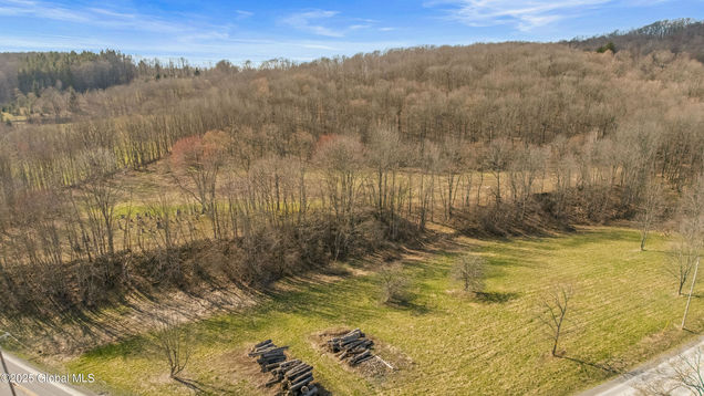
Welcome to L9.111 Lutheranville Rd, Summit, NY, on 12.34 acres of picturesque land in Schoharie County. Boasting several level building tiers with southern exposure, frontage on two roads, woods for hunting and recreation, and a rough driveway in place. Notably, The Snook Cemetery is part of this vast expanse, adding an element of history and character to its allure. Embark on outdoor adventures with ease, as the Catskill Scenic Trail and the captivating slopes of Plattekill Mountain are within reach for nature enthusiasts. For a touch of culture, the Roxbury Arts Group stages a variety of artistic performances and exhibitions throughout the year. When it comes to convenience, it's just approximately 45 minutes to Albany.
![]()
Last checked:
As a licensed real estate brokerage, Estately has access to the same database professional Realtors use: the Multiple Listing Service (or MLS). That means we can display all the properties listed by other member brokerages of the local Association of Realtors—unless the seller has requested that the listing not be published or marketed online.
The MLS is widely considered to be the most authoritative, up-to-date, accurate, and complete source of real estate for-sale in the USA.
Estately updates this data as quickly as possible and shares as much information with our users as allowed by local rules. Estately can also email you updates when new homes come on the market that match your search, change price, or go under contract.
![]() Checking…
•
Last updated May 2, 2025
•
Checking…
•
Last updated May 2, 2025
•
MLS# 202516490 —
This property is listed in more than one place. See it here.
The Building
-
Architectural Style:None
-
Direction Faces:None
-
Foundation Details:None
-
Entry Level:None
Interior
-
Security Features:None
-
Accessibility Features:None
-
Stories:None
-
Fireplace:No
-
Furnished:None
Financial & Terms
-
Possession:At Closing
-
Rent Includes:None
Location
-
Directions:Rte 10 Summit to Charlotte Valley Rd, corner of Lutheranville Rd
-
Directions:Rte 10 Summit to Charlotte Valley Rd, corner of Lutheranville Rd
-
Latitude:42.566056
-
Longitude:-74.640314
The Property
-
Property Type:Land
-
Property Subtype:Unimproved Land
-
Lot Features:Road Frontage, Mixed Timber, Level, Meadow, Mineral Rights Included, Private, Secluded, Views, Wooded, Hilly, Corner Lot
-
Lot Size Area:12.34
-
Lot Size Acres:12.34
-
Lot Size Units:Acres
-
Lot Size SqFt:537530.4
-
Possible Use:None
-
Parcel Number:122.-3-9.111 434800
-
Corner Lot:true
-
Topography:None
-
Views:true
-
Waterfront:No
-
Other Structures:None
-
Main Road Frontage:856.0
Listing Agent
- Contact info:
- Agent phone:
- (607) 434-5993
- Office phone:
- (607) 397-9027
Taxes
-
Tax Annual Amount:1200.0
Baths
-
Three Quarter Baths:None
-
Quarter Baths:None
Heating & Cooling
-
Cooling:No
-
Heating:No
Utilities
-
Utilities:Cable Available, Electricity Available, Phone Available
-
Sewer:None
-
Water Source:None
Schools
-
Elementary School District:None
-
Middle Or Junior School District:None
-
Middle Or Junior School:None
-
High School District:Cobleskill-Richmondville
The Community
-
Pool Private:No
-
Spa Features:None
-
Waterfront:false
-
Pets Allowed:None
-
Association:false
-
Association Fee Includes:None
Parking
-
Carport Spaces:None
-
Open Parking:No
Walk Score®
Provided by WalkScore® Inc.
Walk Score is the most well-known measure of walkability for any address. It is based on the distance to a variety of nearby services and pedestrian friendliness. Walk Scores range from 0 (Car-Dependent) to 100 (Walker’s Paradise).
Bike Score®
Provided by WalkScore® Inc.
Bike Score evaluates a location's bikeability. It is calculated by measuring bike infrastructure, hills, destinations and road connectivity, and the number of bike commuters. Bike Scores range from 0 (Somewhat Bikeable) to 100 (Biker’s Paradise).
Sale history
| Date | Event | Source | Price | % Change |
|---|---|---|---|---|
|
5/1/25
May 1, 2025
|
Listed / Active | GLOBAL_MLS | $59,900 |