
Bo Beatriz Fincas Mi Recreo 3, Carr 1
CAGUAS, PR 00725
Map
- – beds
- – baths
- – sqft
- ~5 acre lot
- – on site
More homes
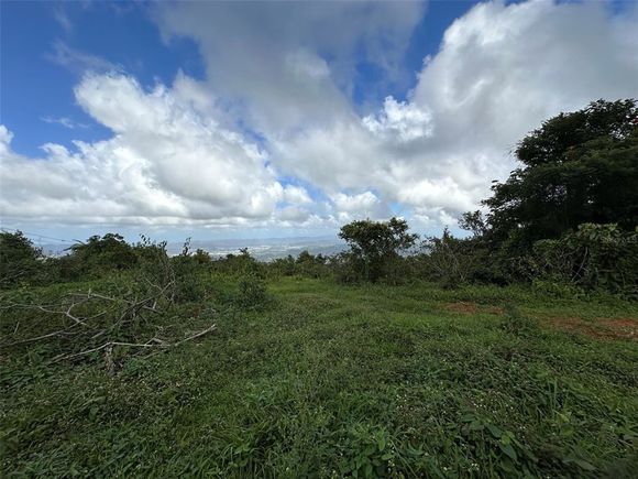
With creek on a boundary. Land Lot of 19,651 sm (4.9 acres), in Beatriz Ward, Sector El Recreo, Caguas. Excellent location, surrounded by nature and tranquility. In SR 1, minutes from PR-52 and Guavate. It has a panoramic view of the mountains. Potential to build your dream homeor start your farming project surrounded by nature. CRIM $430 Annually. Flood Zone: X. Zoning: R-G (General Rural).
![]()
Last checked:
As a licensed real estate brokerage, Estately has access to the same database professional Realtors use: the Multiple Listing Service (or MLS). That means we can display all the properties listed by other member brokerages of the local Association of Realtors—unless the seller has requested that the listing not be published or marketed online.
The MLS is widely considered to be the most authoritative, up-to-date, accurate, and complete source of real estate for-sale in the USA.
Estately updates this data as quickly as possible and shares as much information with our users as allowed by local rules. Estately can also email you updates when new homes come on the market that match your search, change price, or go under contract.
![]() Checking…
•
Last updated Oct 21, 2024
•
Checking…
•
Last updated Oct 21, 2024
•
MLS# PR9104233 —
The Building
-
Building Area Units:Square Feet
Room Dimensions
-
Living Area Units:Square Feet
Location
-
Directions:Luis Muñoz Marin International Airport Airport Rd, Carolina, 00979 Get on Expreso Las Américas/PR-18 in Gobernador Piñero, San Juan from Av. Jesús T. Piñero/PR-17 10 min (9.5 km) Take PR-52 to Carr. 184/PR-184. Take exit 32 from Autop. Luis A. Ferré/PR-52 24 min (35.4 km) Merge onto Expreso Las Américas/PR-18 3.3 km Continue straight onto PR-52 Toll road. 1.0 km Keep left to continue on Autop. Luis A. Ferré/PR-52 Toll road. 2.6 km Keep left to stay on Autop. Luis A. Ferré/PR-52 Toll road. 10.3 km Continue straight to stay on Autop. Luis A. Ferré/PR-52 Toll road. 17.7 km Take exit 32 for Puerto Rico 184 toward Cidra/Puerto Rico 1/Guavate/Cayey Este Toll road. 450 m Take PR-1 N to your destination in Las Piñas 11 min (5.8 km) Turn right onto Carr. 184/PR-184 130 m Turn right onto PR-1 N 2.3 km Turn right 1.5 km Keep right 1.6 km Turn right Destination will be on the left
-
Latitude:18.156166
-
Longitude:-66.075428
-
Coordinates:-66.075428, 18.156166
The Property
-
Parcel Number:27600001055000
-
Property Type:Land
-
Lot Size Acres:4.85
-
Lot Size Area:4.8559
-
Lot Size SqFt:211521
-
Lot Size Dimensions:19,651
-
Lot Size Units:Acres
-
Total Acres:2 to less than 5
-
Zoning:R-G
-
Current Use:Unimproved
-
View:Mountain(s)
-
View:true
-
Water Source:None
-
Road Surface Type:Asphalt
-
Flood Zone Code:X
-
Additional Parcels:false
-
Price Per Acre:13402
Listing Agent
- Contact info:
- Agent phone:
- (787) 378-2652
- Office phone:
- (787) 380-3296
The Listing
-
Special Listing Conditions:None
Utilities
-
Utilities:Electrical Nearby
-
Sewer:None
The Community
-
Subdivision Name:BO BEATRIZ SECTOR MI RECREO
-
Waterview:false
-
Water Access:false
-
Waterfront:false
-
Ownership:Fee Simple
Walk Score®
Provided by WalkScore® Inc.
Walk Score is the most well-known measure of walkability for any address. It is based on the distance to a variety of nearby services and pedestrian friendliness. Walk Scores range from 0 (Car-Dependent) to 100 (Walker’s Paradise).
Sale history
| Date | Event | Source | Price | % Change |
|---|---|---|---|---|
|
6/14/24
Jun 14, 2024
|
Sold | STELLAR_MLS | $65,000 | -17.7% |
|
2/27/24
Feb 27, 2024
|
Price Changed | STELLAR_MLS | $79,000 | -11.2% |
|
1/29/24
Jan 29, 2024
|
Listed / Active | STELLAR_MLS | $89,000 |