


Bb Highway
Corder, MO 64021
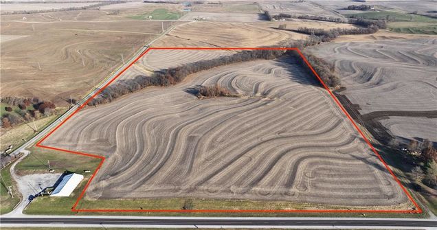
Map
- – beds
- – baths
- – sqft
- ~61 acre lot
- – on site
More homes
61 Lafayette County acres located off 20 Hwy and BB in Corder, MO. 53 are highly productive, tillable, and less than ½ mile from Ray-Carroll. The 2016 USDA corn yield was 207 bushels and the 2017 soybean yield was 56. Lafayette County is well known for prime farm ground and this land is no different. Offers received will be reviewed Friday, November 24th up to 5 PM. Don’t let this opportunity pass you by!
![]()
Last checked:
As a licensed real estate brokerage, Estately has access to the same database professional Realtors use: the Multiple Listing Service (or MLS). That means we can display all the properties listed by other member brokerages of the local Association of Realtors—unless the seller has requested that the listing not be published or marketed online.
The MLS is widely considered to be the most authoritative, up-to-date, accurate, and complete source of real estate for-sale in the USA.
Estately updates this data as quickly as possible and shares as much information with our users as allowed by local rules. Estately can also email you updates when new homes come on the market that match your search, change price, or go under contract.
![]() Checking…
•
Last updated Jul 19, 2024
•
Checking…
•
Last updated Jul 19, 2024
•
MLS# 2463129 —
Financial & Terms
-
Listing Terms:Cash, Conventional
-
Possession:Close Of Escrow
Location
-
Directions:From Higginsville take 20 Hwy E. Property sits on the N side of 20 (see sign) and the E side of BB Hwy (see sign.)
The Property
-
Property Type:Land
-
Property Subtype:Land
-
Parcel Number:08-6.0-23-0-000-006.000
-
Lot Features:Acreage
-
Lot Size SqFt:2657160
-
Lot Size Area:61
-
Lot Size Units:Acres
-
Zoning:Agricultural
-
Current Use:Agriculture
-
Possible Use:Agricultural, Rural
-
Road Responsibility:Public Maintenance
-
Road Surface Type:Paved
-
Topography:Terraced
-
Vegetation:Brush, Crop(s)
-
Crops:None
-
In Flood Plain:No
-
Agriculture Type:Grain/Crops
Listing Agent
- Contact info:
- Agent phone:
- (660) 251-1450
- Office phone:
- (660) 584-5557
Taxes
-
Tax Total Amount:215
Utilities
-
Utilities:None
-
Water Source:No Water
Schools
-
High School District:Lafayette Co CI
The Community
-
Subdivision Name:None
-
Association:false
Walk Score®
Provided by WalkScore® Inc.
Walk Score is the most well-known measure of walkability for any address. It is based on the distance to a variety of nearby services and pedestrian friendliness. Walk Scores range from 0 (Car-Dependent) to 100 (Walker’s Paradise).
Bike Score®
Provided by WalkScore® Inc.
Bike Score evaluates a location's bikeability. It is calculated by measuring bike infrastructure, hills, destinations and road connectivity, and the number of bike commuters. Bike Scores range from 0 (Somewhat Bikeable) to 100 (Biker’s Paradise).
Sale history
| Date | Event | Source | Price | % Change |
|---|---|---|---|---|
|
12/12/23
Dec 12, 2023
|
Sold | HMLS | $640,500 | |
|
11/24/23
Nov 24, 2023
|
Pending | HMLS | $640,500 | |
|
11/21/23
Nov 21, 2023
|
Listed / Active | HMLS | $640,500 |