
77xx S Town Hall Road
Hawthorne Twp, WI 54873
- – beds
- – baths
- – sqft
- – on site
More homes
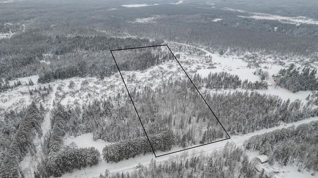
Gorgeous 89.98-acre raw land in Douglas County, Wisconsin. This property is a combination of 3 parcels in Hawthorne perfect for those who love the outdoors. There are 330' of frontage on the Town Hall Rd with the Middle River running through it. Just minutes away from the property are golf courses, lakes, and other attractions like hunting and fishing. There are many snowmobile/ATV/UTV trails nearby including the Wild River State Trail that slightly cuts the back corner of this property. Not to mention being close to Lake Superior and the many N. Central Wisconsin inland lakes. Schedule an appointment to walk this land today!
![]()
Last checked:
As a licensed real estate brokerage, Estately has access to the same database professional Realtors use: the Multiple Listing Service (or MLS). That means we can display all the properties listed by other member brokerages of the local Association of Realtors—unless the seller has requested that the listing not be published or marketed online.
The MLS is widely considered to be the most authoritative, up-to-date, accurate, and complete source of real estate for-sale in the USA.
Estately updates this data as quickly as possible and shares as much information with our users as allowed by local rules. Estately can also email you updates when new homes come on the market that match your search, change price, or go under contract.
![]() Checking…
•
Last updated May 9, 2023
•
Checking…
•
Last updated May 9, 2023
•
MLS# 6337415 —
The Building
-
Development Status:Raw Land
Location
-
Directions:From Superior: South on WI 53 to Right on Co Rd B. Left on Town Hall Rd. Between 7657 & 7751.
-
Latitude:46.484752
-
Longitude:-91.863553
The Property
-
Parcel Number:HA0140028802
-
Zoning Description:Forestry
-
Property Type:Land
-
Property Subtype:Acreage,Recreational
-
Additional Parcels:true
-
Additional Parcels Description:HA0140028700,HA0140029200
-
Lot Features:Tree Coverage - Heavy
-
Lot Size Area:90
-
Lot Size Dimensions:1320x330 + 1320x2640
-
Lot Size Units:Acres
-
Topography:Level,Wooded
-
Lake Chain:N
-
Water Body Name:Middle River
-
Waterfront Slope:Level
-
Waterfront Feet:330
-
Road Frontage Type:Township
-
Road Responsibility:Public Maintained Road
-
Wooded Area:90
-
Land Lease:false
-
Improvements:None
Listing Agent
- Contact info:
- Agent phone:
- (218) 491-1122
- Office phone:
- (218) 728-5161
Taxes
-
Tax Year:2022
-
Tax Annual Amount:1016
-
Tax With Assessments:1015.8300
Utilities
-
Utilities:None Connected, Electricity Available, Private Septic Available, Private Well Available
Schools
-
High School District:Maple
The Community
-
Waterfront:true
-
Waterfront Features:Creek/Stream
-
Association:false
-
Assessment Pending:No
Walk Score®
Provided by WalkScore® Inc.
Walk Score is the most well-known measure of walkability for any address. It is based on the distance to a variety of nearby services and pedestrian friendliness. Walk Scores range from 0 (Car-Dependent) to 100 (Walker’s Paradise).
Sale history
| Date | Event | Source | Price | % Change |
|---|---|---|---|---|
|
5/5/23
May 5, 2023
|
Sold | NORTHSTAR | $128,500 | -5.9% |
|
2/28/23
Feb 28, 2023
|
Listed / Active | NORTHSTAR | $136,500 |