

6991 Township Road 555
Holmesville, OH 44633
Map
- – beds
- – baths
- – sqft
- 5 sqft lot
- – on site
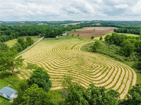
120.3 acres in 11 parcels with a great selection of open/tillable land along with wooded/recreational hunting land and in an excellent location between Millersburg and Shreve. The farm has over 6,800 feet of road frontage on TR 555 & TR 551. Improvements include a solid 2 story farmhouse that was originally built in the 1800s with additions and renovations done in 1979. The exterior features plenty of Briar Hill sandstone. The interior has plenty of cherry wood panels and trim from lumber harvested right off the Rohr farm. Updated roof, windows and exterior doors. Outbuildings include a newer 24’x30’ detached garage, 52’x 80’ machinery shed, an older bank barn and several older outbuildings. The land offers a good variety of open and wooded parcels with some mature trees ready for harvest in the next 5-10 years.
![]()
Last checked:
As a licensed real estate brokerage, Estately has access to the same database professional Realtors use: the Multiple Listing Service (or MLS). That means we can display all the properties listed by other member brokerages of the local Association of Realtors—unless the seller has requested that the listing not be published or marketed online.
The MLS is widely considered to be the most authoritative, up-to-date, accurate, and complete source of real estate for-sale in the USA.
Estately updates this data as quickly as possible and shares as much information with our users as allowed by local rules. Estately can also email you updates when new homes come on the market that match your search, change price, or go under contract.
![]() Checking…
•
Last updated Jul 14, 2025
•
Checking…
•
Last updated Jul 14, 2025
•
MLS# 5136696 —
This property is listed in more than one place. See it here, and here, and here, and here, and here, and here, and here, and here, and here, and here, and here.
Room Dimensions
-
Living Area Units:SquareFeet
Financial & Terms
-
Possession:DeliveryOfDeed
Location
-
Directions:Directions: From Holmesville take CR 320 West 3.5 miles to TR 555. Take TR 555 north ½ mile to property. Signs posted. GPS coordinates are 40.60672, -81.97750.
-
Longitude:-81.976307
-
Latitude:40.606321
The Property
-
Property Type:Land
-
Property Subtype:Farm
-
Property Subtype Additional:Farm
-
# of Lots:1
-
Parcel Number:17-00384.006
-
Lot Size Acres:5.0
-
Lot Size Area:5.0
-
Lot Size Units:Acres
-
Lot Size Source:Assessor
Listing Agent
- Contact info:
- Agent phone:
- (330) 231-1914
- Office phone:
- (330) 852-4111
Taxes
-
Tax Year:2024
-
Tax Legal Description:R13 T13 S18 120.313ACCOMB & RES 3/20/17PR-1
The Listing
-
Special Listing Conditions:Auction
Utilities
-
Utilities:SewerNotAvailable,WaterNotAvailable
-
Sewer:None
-
Water Source:None
Schools
-
Elementary School District:Waynedale (Southeast) LSD Wayne- 8508
-
Middle School District:Waynedale (Southeast) LSD Wayne- 8508
-
High School District:Waynedale (Southeast) LSD Wayne- 8508
The Community
-
Association:false
Parking
-
Parking Features:None
-
Attached Garage:false
Walk Score®
Provided by WalkScore® Inc.
Walk Score is the most well-known measure of walkability for any address. It is based on the distance to a variety of nearby services and pedestrian friendliness. Walk Scores range from 0 (Car-Dependent) to 100 (Walker’s Paradise).
Bike Score®
Provided by WalkScore® Inc.
Bike Score evaluates a location's bikeability. It is calculated by measuring bike infrastructure, hills, destinations and road connectivity, and the number of bike commuters. Bike Scores range from 0 (Somewhat Bikeable) to 100 (Biker’s Paradise).
Sale history
| Date | Event | Source | Price | % Change |
|---|---|---|---|---|
|
7/14/25
Jul 14, 2025
|
Pending | MLS_NOW | $1 | |
|
7/2/25
Jul 2, 2025
|
Listed / Active | MLS_NOW | $1 |