
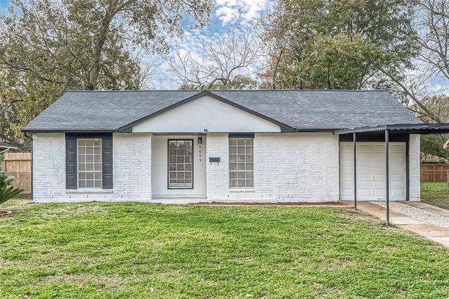
6009 Maywood Drive
Houston, TX 77053
Map
- 4 beds
- 2 baths
- 1,314 sqft
- 7,801 sqft lot
- $163 per sqft
- 1976 build
- – on site
More homes
Welcome to 6009 Maywood Drive LOCATED located in the beautiful Mayfair Park subdivision zoned to Fort Bend ISD! This gorgeous property has been beautifully upgraded and it is priced to sell quick! This home features 4 bedrooms, 1 full bath, 1 half bath with a little over 1,300 sqft of space. Stepping into the property, you're greeted with a grand floor plan, filled with new upgrades! This home features FRESH paint, NEW flooring, a NEW toilet, NEW countertops, NEW appliances, NEW faucets, NEW doorknobs, NEW light fixtures, and NEW ceiling fans!! Step out onto the backyard, which includes perfect space for your furry- friends to run around in! This home will not last long, schedule your showing today!
![]()
Last checked:
As a licensed real estate brokerage, Estately has access to the same database professional Realtors use: the Multiple Listing Service (or MLS). That means we can display all the properties listed by other member brokerages of the local Association of Realtors—unless the seller has requested that the listing not be published or marketed online.
The MLS is widely considered to be the most authoritative, up-to-date, accurate, and complete source of real estate for-sale in the USA.
Estately updates this data as quickly as possible and shares as much information with our users as allowed by local rules. Estately can also email you updates when new homes come on the market that match your search, change price, or go under contract.
![]() Checking…
•
Last updated Jun 9, 2025
•
Checking…
•
Last updated Jun 9, 2025
•
MLS# 82261778 —
The Building
-
Year Built:1976
-
Year Built Source:Appraisal District
-
Architectural Style:Traditional
-
New Construction:false
-
Construction Materials:Brick
-
Structure Type:Free Standing
-
Roof:Composition
-
Foundation Details:Slab
Interior
-
Living Area:1314
-
Living Area Units:Square Feet
-
Stories:1
Location
-
Longitude:-95.474197
-
Latitude:29.602088
The Property
-
Property Type:Residential
-
Property Sub Type:Single Family Residence
-
Parcel Number:4850000391000907
-
Lot Features:Subdivided
-
Lot Size Area:0.1791
-
Lot Size Acres:0.1791
-
Lot Size Square Feet:7,801 Sqft
-
Lot Size Units:Acres
-
Lot Size Source:Appraisal District
Listing Agent
- Contact info:
- Agent phone:
- 1(713) 545-3936
- Office phone:
- (713) 545-3936
Taxes
-
Tax Year:2023
-
Tax Annual Amount:$2,606
Beds
-
Bedrooms Total:4
Baths
-
Bathrooms Full:1
-
Bathrooms Half:1
-
Bathrooms Total:2
Heating & Cooling
-
Cooling:Electric
-
Cooling:true
-
Heating:Natural Gas
-
Heating:true
Utilities
-
Water Source:Public
Appliances
-
Appliances:Disposal
Schools
-
Elementary School:Ridgegate Elementary School
-
Middle School:Mcauliffe Middle School
-
High School District:19 - Fort Bend
-
High School:Willowridge High School
The Community
-
Subdivision Name:Mayfair Park
-
Pool Private:false
Parking
-
Garage:false
-
Carport:false
Walk Score®
Provided by WalkScore® Inc.
Walk Score is the most well-known measure of walkability for any address. It is based on the distance to a variety of nearby services and pedestrian friendliness. Walk Scores range from 0 (Car-Dependent) to 100 (Walker’s Paradise).
Bike Score®
Provided by WalkScore® Inc.
Bike Score evaluates a location's bikeability. It is calculated by measuring bike infrastructure, hills, destinations and road connectivity, and the number of bike commuters. Bike Scores range from 0 (Somewhat Bikeable) to 100 (Biker’s Paradise).
Transit Score®
Provided by WalkScore® Inc.
Transit Score measures a location's access to public transit. It is based on nearby transit routes frequency, type of route (bus, rail, etc.), and distance to the nearest stop on the route. Transit Scores range from 0 (Minimal Transit) to 100 (Rider’s Paradise).
Soundscore™
Provided by HowLoud
Soundscore is an overall score that accounts for traffic, airport activity, and local sources. A Soundscore rating is a number between 50 (very loud) and 100 (very quiet).
Air Pollution Index
Provided by ClearlyEnergy
The air pollution index is calculated by county or urban area using the past three years data. The index ranks the county or urban area on a scale of 0 (best) - 100 (worst) across the United Sates.