
5392 Hwy 90
Pace, FL 32571
Map
- – beds
- – baths
- – sqft
- ~2 acre lot
- – on site
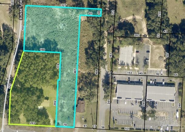
1.7 ACRES zoned Highway Commercial Development. This property is located between Milton and Pace just east of Lowe's Home Improvement; shaded in green. This parcel has access from the side street, Sunset Drive with 197 feet of road frontage. It has 79 feet of road frontage on Hwy 90. The adjoining 1.5 acre parcel to the west is also for sale with 203 ft of road frontage on Hwy 90; shaded in yellow. These parcels are listed seperately but if purchased together would give over 3 acres of HCD zoned property in the rapidly developing Florida Panhandle.
![]()
Last checked:
As a licensed real estate brokerage, Estately has access to the same database professional Realtors use: the Multiple Listing Service (or MLS). That means we can display all the properties listed by other member brokerages of the local Association of Realtors—unless the seller has requested that the listing not be published or marketed online.
The MLS is widely considered to be the most authoritative, up-to-date, accurate, and complete source of real estate for-sale in the USA.
Estately updates this data as quickly as possible and shares as much information with our users as allowed by local rules. Estately can also email you updates when new homes come on the market that match your search, change price, or go under contract.
![]() Checking…
•
Last updated Jul 17, 2025
•
Checking…
•
Last updated Jul 17, 2025
•
MLS# 667922 —
The Building
-
Building Area Units:Square Feet
Room Dimensions
-
Living Area Units:Square Feet
Location
-
Directions:Hwy 90, between Milton and Pace on the north side of the hwy. East of Lowes.
-
Latitude:30.60401047
-
Longitude:-87.098845169
The Property
-
Parcel Number:121N290000010000000
-
Property Type:Land
-
Property Subtype:Land/Acreage
-
Lot Size Acres:1.7
-
Lot Size Area:1.7
-
Lot Size SqFt:74052
-
Lot Size Units:Acres
-
Zoning Description:Commercial
-
Horse:false
-
Road Frontage Type:County Road
-
Land Lease Amount Frequency:Annually
Listing Agent
- Contact info:
- Agent phone:
- (850) 982-7991
- Office phone:
- (850) 916-5050
Taxes
-
Tax Legal Description:*DESCRIPTION UPDATED FOR 2022* COM ON E LN OF SECTION 12 TOWNSHP 1 NORTH RANGE 29 WEST AT THE N R/W OF U S HWY 90 THN N87*13'38"W ON N R/W 92.53 FT TO POB & CONT ON R/W 77.97 FT THN N2*55'21"E 202.44 FT THN S89*46'15"E 7 FT THN N2*54 '15"E 122.20 FT THN N87*48'33" W 160.02 FT TO E R/W OF SUNSET DR THN N2*54'25"E ON R/W 200. 04 FT THN S87*48'32"E 160.01 FT THNS87*48'32"E 163.96 FT TO E SEC LN THN S2*57'30"W ON SEC LN 30 FT THN N87*48'32"W 90.46 FT THN S3*11'57"W 495.75 FT TO POB AS DES IN OR 3738 PG 639 (ADDED TO OUT OF #9 FOR 2018)
Utilities
-
Sewer:None
-
Water Source:None
Schools
-
Elementary School:Pea Ridge
-
Middle Or Junior School:AVALON
-
High School:Pace
The Community
-
Subdivision Name:None
Soundscore™
Provided by HowLoud
Soundscore is an overall score that accounts for traffic, airport activity, and local sources. A Soundscore rating is a number between 50 (very loud) and 100 (very quiet).
Sale history
| Date | Event | Source | Price | % Change |
|---|---|---|---|---|
|
7/17/25
Jul 17, 2025
|
Listed / Active | PAR | $500,000 |