


332 Wolf Fork Road
Dayton, WA 99328
Map
- – beds
- – baths
- – sqft
- ~1715 acre lot
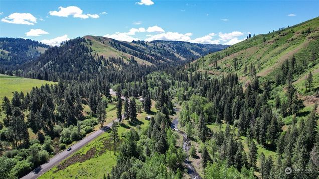
Wolf Fork Creek & Robinson Creek traverse this land once known as the Dr. W.W. Day Ranch. Just 15 min from Dayton WA, and 30 min from Bluewood Ski Area. Currently leased for cattle pasture. Consider it for a residence, getaway cabin, or agricultural pursuits—pending necessary permits. Hunt big game like bear, elk, cougar, and deer, and enjoy abundant wild birds and turkeys. Fish for trout in pristine waters. The property includes Pine, Douglas Fir & White Fir. A nature lover's dream. From fishing to skiing, explore outdoor recreation in this scenic region, near Lyons Ferry Marina, Palouse Falls, Umatilla National Forest, and Walla Walla wine country. A CRP agreement is in place for 10± years, historically yielding $20,000± annually.
![]()
Last checked:
As a licensed real estate brokerage, Estately has access to the same database professional Realtors use: the Multiple Listing Service (or MLS). That means we can display all the properties listed by other member brokerages of the local Association of Realtors—unless the seller has requested that the listing not be published or marketed online.
The MLS is widely considered to be the most authoritative, up-to-date, accurate, and complete source of real estate for-sale in the USA.
Estately updates this data as quickly as possible and shares as much information with our users as allowed by local rules. Estately can also email you updates when new homes come on the market that match your search, change price, or go under contract.
![]() Checking…
•
Last updated May 28, 2025
•
Checking…
•
Last updated May 28, 2025
•
MLS# 2245286 —
The Building
-
Structure Type:Unspecified
-
Building Area Units:Square Feet
Interior
-
Fireplace:false
Financial & Terms
-
Possession:Closing
Location
-
Latitude:46.243797
-
Longitude:-117.900067
-
Directions:From downtown Dayton: Head W on Patit Rd toward E Main St, Turn L onto E Main St, L onto S 4th St, Continue onto N Touchet Rd for a couple of miles until you reach the property.
The Property
-
Property Type:Land
-
Property Subtype:Land
-
Property Features:Pasture Land,Recreational,Stream/Creek
-
Parcel Number:265981
-
Lot Size Units:Square Feet
-
Lot Size Acres:1715.1002
-
Lot Size SqFt:74709900
-
Lot Size Source:Assessor
-
Zoning Description:Agricultural,Farm & Ranch,Forestry
-
Zoning Jurisdiction:County
-
Electric On Property:false
-
View:Mountain(s)
-
View:true
-
Waterfront:false
-
Topography:Sloped
-
Road Surface:Paved
-
Road Information:Paved
-
Possible Use:Agricultural, Forestry
-
Zoning:AR-2 zone
-
Additional Parcels Description:266036,266044,266052,266053,266066,266067,266068,266069,266131,266132
-
Irrigation Water Rights:false
Listing Agent
- Contact info:
- Agent phone:
- (208) 345-3163
- Office phone:
- (208) 345-3163
Taxes
-
Tax Year:2024
-
Tax Annual Amount:2318.45
The Listing
-
Special Listing Conditions:None
Heating & Cooling
-
Cooling:false
-
Heating:false
Utilities
-
Utilities:Electricity Available
-
Water Source:Not Available
-
Sewer:Not Available
-
Electricity Status:In Street
Schools
-
High School District:Dayton
The Community
-
Subdivision Name:Dayton
-
Senior Community:false
-
Association:false
Parking
-
Carport:false
Listing courtesy of NWMLS / Knipe Land North LLC
![]()
Walk Score®
Provided by WalkScore® Inc.
Walk Score is the most well-known measure of walkability for any address. It is based on the distance to a variety of nearby services and pedestrian friendliness. Walk Scores range from 0 (Car-Dependent) to 100 (Walker’s Paradise).
Bike Score®
Provided by WalkScore® Inc.
Bike Score evaluates a location's bikeability. It is calculated by measuring bike infrastructure, hills, destinations and road connectivity, and the number of bike commuters. Bike Scores range from 0 (Somewhat Bikeable) to 100 (Biker’s Paradise).
Sale history
| Date | Event | Source | Price | % Change |
|---|---|---|---|---|
|
2/20/25
Feb 20, 2025
|
Price Changed | NWMLS | $1,995,000 | -25.0% |
|
11/21/24
Nov 21, 2024
|
Price Changed | NWMLS | $2,659,738 | -22.2% |
|
10/2/24
Oct 2, 2024
|
Price Changed | NWMLS | $3,417,000 | -6.9% |