


#717827
Kealakekua, HI 96704
Map
- – beds
- – baths
- – sqft
- ~15 acre lot
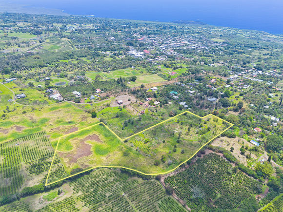
Rarely available 15.15 acre parcel zoned A-5A conveniently located mauka, between and within a short distance of Kainaliu and Kealakekua townships. The approximate median elevation of this parcel is 1,880' and it is accessed from paved Hokukano Road via an easement of way over a 16' wide road.<br>This property has been owned by the same family in excess of 70 years. A portion of the property had been planted in coffee and macadamia, some of which remain, while the remainder is pasture.<br>The property terrain is gentle to moderate sloping and is endowed with significant pockets of soil. Within close proximity are some larger acreage coffee farms which attest to the agricultural potential of this area.<br>Not to be overlooked is the possible subdivision potential of this property.<br><br>Video of property: https://vimeo.com/1057749410/6ffbe87828?share=copy
![]()
Last checked:
As a licensed real estate brokerage, Estately has access to the same database professional Realtors use: the Multiple Listing Service (or MLS). That means we can display all the properties listed by other member brokerages of the local Association of Realtors—unless the seller has requested that the listing not be published or marketed online.
The MLS is widely considered to be the most authoritative, up-to-date, accurate, and complete source of real estate for-sale in the USA.
Estately updates this data as quickly as possible and shares as much information with our users as allowed by local rules. Estately can also email you updates when new homes come on the market that match your search, change price, or go under contract.
![]() Checking…
•
Last updated May 3, 2025
•
Checking…
•
Last updated May 3, 2025
•
MLS# 717827 —
The Building
-
Roofed Area Units:Square Feet
-
Exterior Area Units:Square Feet
Interior
-
Living Area Units:Square Feet
Financial & Terms
-
Listing Terms:1031 Exchange, Cash, Conventional
-
Ownership:Full
-
Land Tenure:Fee Simple
Location
-
Region:North Kona
-
Unparsed Address:KEALAKEKUA, HI 96704
-
Longitude:-155.91441071
-
Latitude:19.52823529
The Property
-
Property Type:Land
-
Zoning:A-5A
-
Lot Features:Grassy, Interior Lot, Ranch
-
Lot Size Dimensions:1542 x 400
-
Lot Size Area:659,890 Sqft
-
Lot Width:400
-
Lot Length:1542
-
Parcel Number:3790100440000
-
Roads:Other, Unpaved
-
Road Frontage Type:Other
-
Topography:Gentle Slope
-
Fencing:Stone
-
Elevation:1790
-
Elevation Units:Feet
-
Frontage Type:Other
-
Flood Zone:X
-
Lava Zone:3
-
Waterfront:false
-
View:Forest, Mountain(s), Ocean, Ocean Horizon, Sunset
-
Structures:false
-
Agriculture Dedicated:false
Listing Agent
- Contact info:
- Agent phone:
- (808) 936-7588
- Office phone:
- (808) 936-7588
Taxes
-
Tax Year:2024
-
Tax Annual Amount:$302.01
-
Tax Lot:32
The Listing
-
Virtual Tour URL:
Utilities
-
Sewer:None
-
Utilities:Phone Available, Water Not Available
-
Water Source:None
-
Internet Access:None
-
Solid Waste Disposal:County-Charge
The Community
-
Subdivision Name:Honuaino 4 Th Kanaueue 1 St & 2 Nd
-
Association Fee Frequency:Monthly
-
Pool:false
Parking
-
Garage Area Units:Square Feet
-
Carport Area Units:Square Feet
Walk Score®
Provided by WalkScore® Inc.
Walk Score is the most well-known measure of walkability for any address. It is based on the distance to a variety of nearby services and pedestrian friendliness. Walk Scores range from 0 (Car-Dependent) to 100 (Walker’s Paradise).
Bike Score®
Provided by WalkScore® Inc.
Bike Score evaluates a location's bikeability. It is calculated by measuring bike infrastructure, hills, destinations and road connectivity, and the number of bike commuters. Bike Scores range from 0 (Somewhat Bikeable) to 100 (Biker’s Paradise).
Sale history
| Date | Event | Source | Price | % Change |
|---|---|---|---|---|
|
5/2/25
May 2, 2025
|
Listed / Active | HISMLS | $1,150,000 |