
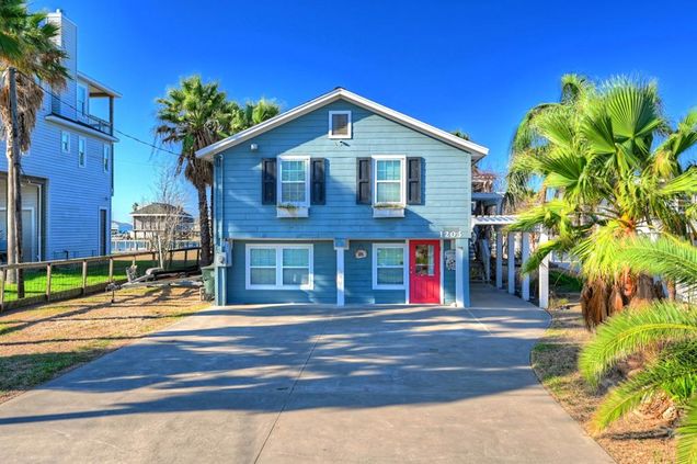
1203 Pilot Lane
Galveston, TX 77554
Map
- 3 beds
- 3 baths
- 2,352 sqft
- 14,348 sqft lot
- $271 per sqft
- 1964 build
- – on site
More homes
Expansive, large water-front lot/home, on the very desirable Crash Boat Basin - 14,350 sq ft lot. Beautiful water views from many locations on the lot and decks. 81 feet of waterfront, rare deep water access allows for a large boat to be moored at your pier. Currently, a 3 bedroom 2 bath home up and a bunk room with a full bath and living area below. Expansive covered deck area above and below. Recreation area & bar below. Boat dock also has a covered area with unobstructed sunset views. The pier and property are protected by harsh north winds. The home has an established short term rental calendar. Plenty of space for family gatherings.
![]()
Last checked:
As a licensed real estate brokerage, Estately has access to the same database professional Realtors use: the Multiple Listing Service (or MLS). That means we can display all the properties listed by other member brokerages of the local Association of Realtors—unless the seller has requested that the listing not be published or marketed online.
The MLS is widely considered to be the most authoritative, up-to-date, accurate, and complete source of real estate for-sale in the USA.
Estately updates this data as quickly as possible and shares as much information with our users as allowed by local rules. Estately can also email you updates when new homes come on the market that match your search, change price, or go under contract.
![]() Checking…
•
Last updated Jul 9, 2025
•
Checking…
•
Last updated Jul 9, 2025
•
MLS# 27998815 —
The Building
-
Year Built:1964
-
Year Built Source:Appraisal District
-
Architectural Style:Traditional
-
New Construction:false
-
Construction Materials:Cement Siding
-
Roof:Composition
-
Foundation Details:Pillar/Post/Pier
-
Exterior Features:Balcony
-
Patio And Porch Features:Patio/Deck
Interior
-
Interior Features:Primary Bed - 2nd Floor
-
Laundry Features:Electric Dryer Hookup
-
Flooring:Wood
-
Living Area:2352
-
Living Area Units:Square Feet
-
Stories:1
Location
-
Longitude:-94.877673
-
Latitude:29.271801
The Property
-
Property Type:Residential
-
Property Sub Type:Single Family Residence
-
Other Structures:Boat House
-
Parcel Number:104500000018100
-
Lot Features:Back Yard
-
Lot Size Area:0.3294
-
Lot Size Acres:0.3294
-
Lot Size Dimensions:270 x 71
-
Lot Size Square Feet:14,348 Sqft
-
Lot Size Units:Acres
-
Lot Size Source:Appraisal District
-
Waterfront Features:Bay Front
-
Waterfront:true
-
Fencing:Back Yard
-
Direction Faces:East
Listing Agent
- Contact info:
- Agent phone:
- 1(832) 247-1311
- Office phone:
- (713) 528-1800
Taxes
-
Tax Year:2020
-
Tax Annual Amount:$8,418
Beds
-
Bedrooms Total:3
Baths
-
Bathrooms Full:3
-
Bathrooms Total:3
Heating & Cooling
-
Cooling:Ceiling Fan(s)
-
Cooling:true
-
Heating:Electric
-
Heating:true
Utilities
-
Sewer:Public Sewer
-
Water Source:Public
Appliances
-
Appliances:Disposal
Schools
-
Elementary School:Gisd Open Enroll
-
Middle School:Gisd Open Enroll
-
High School District:22 - Galveston
-
High School:Ball High School
The Community
-
Subdivision Name:Airport Homesites 2
-
Pool Private:false
Parking
-
Garage:false
-
Carport:false
Walk Score®
Provided by WalkScore® Inc.
Walk Score is the most well-known measure of walkability for any address. It is based on the distance to a variety of nearby services and pedestrian friendliness. Walk Scores range from 0 (Car-Dependent) to 100 (Walker’s Paradise).
Bike Score®
Provided by WalkScore® Inc.
Bike Score evaluates a location's bikeability. It is calculated by measuring bike infrastructure, hills, destinations and road connectivity, and the number of bike commuters. Bike Scores range from 0 (Somewhat Bikeable) to 100 (Biker’s Paradise).
Soundscore™
Provided by HowLoud
Soundscore is an overall score that accounts for traffic, airport activity, and local sources. A Soundscore rating is a number between 50 (very loud) and 100 (very quiet).
Air Pollution Index
Provided by ClearlyEnergy
The air pollution index is calculated by county or urban area using the past three years data. The index ranks the county or urban area on a scale of 0 (best) - 100 (worst) across the United Sates.