


12 Acres Critton Owl Hollow Road
SLANESVILLE, WV 25444
Map
- – beds
- – baths
- – sqft
- ~12 acre lot
More homes
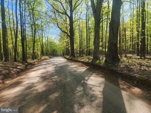
GORGEOUS , LEVEL, 12 ACRE PARCEL WITH TOWERING HARDWOODS, MINIMAL RESTRICTIONS, NO HOA, AND LOCATED ON A STATE MAINTAINED - PAVED ROAD. SOUNDS PRETTY GOOD - DOESN'T IT? WELL, THAT'S BECAUSE IT IS! ACREAGE THIS SIZE IN THIS LOCATION WITH THESE ATTRIBUTES IS HARD TO COME BY. IF YOU'VE BEEN LOOKING, THEN YOU KNOW. DON'T MISS YOUR CHANCE TO OWN A PIECE OF MOUNTAIN STATE PARADISE - CHECK IT OUT TODAY!
![]()
Last checked:
As a licensed real estate brokerage, Estately has access to the same database professional Realtors use: the Multiple Listing Service (or MLS). That means we can display all the properties listed by other member brokerages of the local Association of Realtors—unless the seller has requested that the listing not be published or marketed online.
The MLS is widely considered to be the most authoritative, up-to-date, accurate, and complete source of real estate for-sale in the USA.
Estately updates this data as quickly as possible and shares as much information with our users as allowed by local rules. Estately can also email you updates when new homes come on the market that match your search, change price, or go under contract.
![]() Checking…
•
Last updated Jun 26, 2025
•
Checking…
•
Last updated Jun 26, 2025
•
MLS# WVHS2006058 —
Financial & Terms
-
Sale Type:Standard
-
Acceptable Financing:Cash, Conventional
-
Buyer Financing:Cash
-
Possession:Settlement
Location
-
Directions:IF COMING FROM RT 29 AT THE SLANESVILLE END, TAKE CRITTON OWL HOLLOW RD. 4 MILES TO PROPERTY ON LEFT. IF COMING FROM THE PAW PAW END TAKE CRITTON OWL HOLLOW RD. APPROXIMATELY 4 MILES TO PROPERTY ON RIGHT. FOR GPS , THE ADJOINING RESIDENCE HAS AN ADDRESS OF 4028 CRITTON OWL HOLLOW RD. SLANESVILLE, WV 25444
-
Latitude:39.43647195
-
Longitude:-78.47740029
-
Location Type:Rural
The Property
-
Property Type:Land
-
Property Subtype:Land
-
Current Use:Vacant
-
Lot Size Units:Square Feet
-
Lot Size Acres:12.01
-
Lot Size Source:Assessor
-
Lot Features:Level, Road Frontage, Rural, Trees/Wooded
-
Lot SqFt:523,156 Sqft
-
Additional Parcels:No
-
Zoning:100
-
Road Surface Type:Black Top
-
Road Responsibility:State
-
View:Trees/Woods
-
In City Limits:No
-
Waterview:No
-
Topography Description:LEVEL TO GENTLY SLOPING
-
Waterfront:No
-
Water Oriented:No
-
Water Access:No
-
Navigable Water:No
-
Tidal Water:No
-
Farm Land Preservation:No
-
Land Use Code:004
-
Riparian Rights:No
Listing Agent
- Contact info:
- Agent phone:
- (240) 362-5545
- Office phone:
- (304) 822-4488
Taxes
-
Tax ID Number:01 9A001800000000
-
Tax Year:2022
-
Tax Lot:2
-
Tax Annual Amount:$278
-
Tax Assessed Value:$26,500
-
Year Assessed:2022
-
School Tax:172.0
-
County Tax:93.00
-
Total Taxes Payment Frequency:Annually
The Listing
-
Close Sale Type:Standard Sale
Utilities
-
Sewer/Septic:No Septic System
-
Water Source:Well Required
Schools
-
High School:HAMPSHIRE
-
School District Name:Hampshire County Schools
-
School District Source:Listing Agent
The Community
-
Subdivision Name:Spring Gap Mountain
-
HOA:No
Extra Units
-
Vacation Rental:No
Walk Score®
Provided by WalkScore® Inc.
Walk Score is the most well-known measure of walkability for any address. It is based on the distance to a variety of nearby services and pedestrian friendliness. Walk Scores range from 0 (Car-Dependent) to 100 (Walker’s Paradise).
Bike Score®
Provided by WalkScore® Inc.
Bike Score evaluates a location's bikeability. It is calculated by measuring bike infrastructure, hills, destinations and road connectivity, and the number of bike commuters. Bike Scores range from 0 (Somewhat Bikeable) to 100 (Biker’s Paradise).
Sale history
| Date | Event | Source | Price | % Change |
|---|---|---|---|---|
|
6/26/25
Jun 26, 2025
|
Sold | BRIGHT | $85,000 | |
|
5/27/25
May 27, 2025
|
Pending | BRIGHT | $85,000 | |
|
5/20/25
May 20, 2025
|
Relisted | BRIGHT | $85,000 |