

0 Spiral Lane
North Port, FL 34288
Map
- – beds
- – baths
- – sqft
- 14,148 sqft lot
- – on site
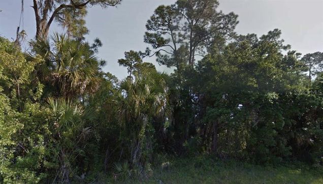
This vacant lot on Spiral Lane is located in a peaceful, developing area of North Port. Surrounded by natural Florida landscape and a mix of new and future homes, this parcel offers a great opportunity for custom home construction or long-term investment. Enjoy the privacy of a quiet street with convenient access to shopping, schools, I-75, and Gulf Coast beaches. All information is deemed reliable but should be independently verified.
![]()
Last checked:
As a licensed real estate brokerage, Estately has access to the same database professional Realtors use: the Multiple Listing Service (or MLS). That means we can display all the properties listed by other member brokerages of the local Association of Realtors—unless the seller has requested that the listing not be published or marketed online.
The MLS is widely considered to be the most authoritative, up-to-date, accurate, and complete source of real estate for-sale in the USA.
Estately updates this data as quickly as possible and shares as much information with our users as allowed by local rules. Estately can also email you updates when new homes come on the market that match your search, change price, or go under contract.
![]() Checking…
•
Last updated Jul 19, 2025
•
Checking…
•
Last updated Jul 19, 2025
•
MLS# O6328373 —
The Building
-
Building Area Units:Square Feet
Room Dimensions
-
Living Area Units:Square Feet
Location
-
Directions:From I-75, take Exit 179 for Toledo Blade Boulevard and head south. Continue for approximately 3 miles, then turn left onto Price Boulevard. After 2 miles, turn right onto Atwater Drive. Continue for 1.5 miles and turn left onto Spiral Lane. The lot is located on the right-hand side, mid-block.
-
Latitude:27.07060245
-
Longitude:-82.06529717
-
Coordinates:-82.06529717, 27.07060245
The Property
-
Parcel Number:1127227927
-
Property Type:Land
-
Lot Size Acres:0.32
-
Lot Size Area:14148
-
Lot Size SqFt:14148
-
Lot Size Dimensions:174 x 81
-
Lot Size Units:Square Feet
-
Total Acres:1/4 to less than 1/2
-
Zoning:RSF2
-
Current Use:Residential
-
Direction Faces:East
-
View:false
-
Water Source:None
-
Road Responsibility:Public Maintained Road
-
Road Surface Type:Asphalt
-
Flood Zone Code:X
-
Flood Zone Panel:12115C0404F
-
Additional Parcels:false
-
Price Per Acre:56250
Listing Agent
- Contact info:
- Agent phone:
- (407) 399-3674
- Office phone:
- (407) 399-3674
Taxes
-
Tax Year:2024
-
Tax Lot:27
-
Tax Block:2279
-
Tax Legal Description:LOT 27 BLK 2279 47TH ADD TO PORT CHARLOTTE
-
Tax Book Number:19-46
-
Tax Annual Amount:$496
The Listing
-
Special Listing Conditions:None
Utilities
-
Utilities:Other
-
Sewer:None
Schools
-
Elementary School:Atwater Bay Elementary
-
Middle Or Junior School:Woodland Middle School
-
High School:North Port High
The Community
-
Subdivision Name:PORT CHARLOTTE SUB 47
-
Waterview:false
-
Water Access:false
-
Waterfront:false
-
Association:false
-
Ownership:Fee Simple
Walk Score®
Provided by WalkScore® Inc.
Walk Score is the most well-known measure of walkability for any address. It is based on the distance to a variety of nearby services and pedestrian friendliness. Walk Scores range from 0 (Car-Dependent) to 100 (Walker’s Paradise).
Bike Score®
Provided by WalkScore® Inc.
Bike Score evaluates a location's bikeability. It is calculated by measuring bike infrastructure, hills, destinations and road connectivity, and the number of bike commuters. Bike Scores range from 0 (Somewhat Bikeable) to 100 (Biker’s Paradise).
Transit Score®
Provided by WalkScore® Inc.
Transit Score measures a location's access to public transit. It is based on nearby transit routes frequency, type of route (bus, rail, etc.), and distance to the nearest stop on the route. Transit Scores range from 0 (Minimal Transit) to 100 (Rider’s Paradise).
Sale history
| Date | Event | Source | Price | % Change |
|---|---|---|---|---|
|
7/18/25
Jul 18, 2025
|
Listed / Active | STELLAR_MLS | $18,000 |