
301 E Mountain View Street
Barstow, CA 92311
Map
- – beds
- – baths
- – sqft
- ~10 acre lot
- – on site
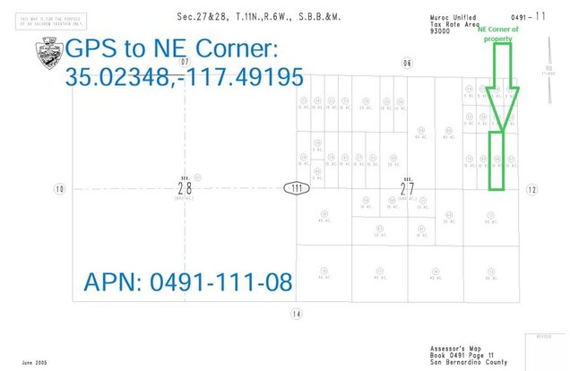
10 Acres (APN: 0491-111-08) GPS: 35.023480, -117.491950 The parcel is located northeast of Kramer Junction near Barstow. This property lies within the unincorporated area of the San Bernardino County within the 'Resource Conservation (RC)' zoning. According to the County this land use designation zoning district provides for open space and recreational activities and single family homes. Some of the other permitted uses include; crop production, orchard, vineyard, produce stand and a licensed residential care facility. Development in the Kramer Junction area is mostly solar. Quite a bit of property in the area is managed by the Bureau of Land Management (BLM). The BLM is a government agency that manages public lands for a variety of uses for the enjoyment of present and future generations. Approximately 11 million acres, of its 25 million acres, is protected and preserved as the California Desert Conservation Area. These public lands and off road trails can be used, per the BLM rules. This property does not yet have an address. While the boundary lines on the map offer a glimpse, they are only approximate. A Buyer should verify boundaries, zoning and utilities, ensuring every aspect aligns with their vision for the property.
![]()
Last checked:
As a licensed real estate brokerage, Estately has access to the same database professional Realtors use: the Multiple Listing Service (or MLS). That means we can display all the properties listed by other member brokerages of the local Association of Realtors—unless the seller has requested that the listing not be published or marketed online.
The MLS is widely considered to be the most authoritative, up-to-date, accurate, and complete source of real estate for-sale in the USA.
Estately updates this data as quickly as possible and shares as much information with our users as allowed by local rules. Estately can also email you updates when new homes come on the market that match your search, change price, or go under contract.
![]() Checking…
•
Last updated Jan 17, 2025
•
Checking…
•
Last updated Jan 17, 2025
•
MLS# HD24201400 —
The Building
-
New Construction:No
Location
-
Directions:Exit Highway 58 at Highway 395 and turn north on Highway 395 and go approx 2.2 miles, right onto Farmington Rd and go 3.4 miles, right onto dirt trail and go 0.25 mi. Property is aprx 330 ft east. GPS: 35.023480, -117.491950
-
Latitude:35.02299300
-
Longitude:-117.49256200
The Property
-
Property Type:Land
-
Zoning:RC
-
Zoning Description:Resource Conservation
-
Lot Features:Desert Back, Desert Front, Horse Property, Lot Over 40000 Sqft
-
Lot Size Area:435600.0000
-
Lot Size Acres:10.0000
-
Lot Size SqFt:435600.00
-
Lot Size Source:Assessor
-
View:1
-
View:Desert, Mountain(s), Valley
-
Fencing:None
-
Current Use:Unimproved
-
Possible Use:Recreational, Residential
-
Road Frontage:Country Road
-
Road Surface Type:Unpaved
-
Additional Parcels:No
-
Land Lease:No
Listing Agent
- Contact info:
- No listing contact info available
Taxes
-
Tax Census Tract:94.00
The Listing
-
Special Listing Conditions:Standard
-
Parcel Number:0491111080000
Utilities
-
Utilities:None
-
Sewer:None
-
Water Source:None
The Community
-
Features:BLM/National Forest
-
Association:No
-
Senior Community:No
-
Distance To Water Comments:unknown
-
Distance To Electric Comments:+3Mi
Walk Score®
Provided by WalkScore® Inc.
Walk Score is the most well-known measure of walkability for any address. It is based on the distance to a variety of nearby services and pedestrian friendliness. Walk Scores range from 0 (Car-Dependent) to 100 (Walker’s Paradise).
Bike Score®
Provided by WalkScore® Inc.
Bike Score evaluates a location's bikeability. It is calculated by measuring bike infrastructure, hills, destinations and road connectivity, and the number of bike commuters. Bike Scores range from 0 (Somewhat Bikeable) to 100 (Biker’s Paradise).
Sale history
| Date | Event | Source | Price | % Change |
|---|---|---|---|---|
|
9/27/24
Sep 27, 2024
|
Listed / Active | CRMLS_CA | $15,600 |